IRF World Road Statistics: Difference between revisions
Greg.Gillen (talk | contribs) (Pulling instructions page created) |
Norah.Shamin (talk | contribs) No edit summary |
||
| (5 intermediate revisions by 3 users not shown) | |||
| Line 1: | Line 1: | ||
== | = Summary = | ||
The International Road Federation (IRF) maintains a database known as World Road Statistics (WRS), comprising over 200 series for over 200 countries. The database is a tremendous resource for infrastructure data, specifically transportation network data. WRS contains information on total road length, but also contains filters to view paved vs. unpaved roads, the kinds of traffic (commercial vs. private), the vehicles using the roadway, accidents and the consequences of them, and more. | |||
To IFs, the IRF provides an important window into the transportation infrastructure of a country. A robust, paved road network makes it easier for a country's exporters to access ports, and for its citizens to find jobs if they are scarce locally. IFs uses three preprocessors from this data source: RoadsPavedKm, the total length of paved roads in a country measured in kilometers; RoadsTotalNetwork, the total length of roads paved or unpaved; and RoadsPaved%, the proportion of the total network which is paved. | |||
[[File:IRF world Road.png| | Another table is usually updated with these three preprocessors: RuralAccessIndex. Yhe Rural Access Index measures the proportion of the rural population who live within 2 km of an all-season road. It is included in the Sustainable Development Goals as indicator 9.1.1., providing a way of measuring progress towards Goal 9 and Target 9.1. This table is pulled from the [https://datacatalog.worldbank.org/search/dataset/0038250 World Bank]. | ||
[[File: | |||
[[File: | The latest update in IFs was in April 2025. | ||
[[File: | |||
= Tables In IFs = | |||
{| class="wikitable" | |||
|Table | |||
|Definition | |||
|Extended Source Definition | |||
|Unit | |||
|Years | |||
|Source | |||
|Name in Source | |||
|Preprocessor Name | |||
|- | |||
|SeriesRoadRuralAccessIndex | |||
|Rural Access Index, proportion of the rural population who live within 2 km (25 minute walk) of all-weather road | |||
|RAI estimates the number of people who live within 2 kilometers (or about 25 minutes walking time) of the nearest all-weather road (Roberts, KC, and Rastogi 2006) | |||
|Index | |||
|1993-2004,2009-2022 | |||
|Rural Access Index, World Bank | |||
|Rural Access Index | |||
|INFRASTRUCTURE | |||
|- | |||
|SeriesRoadsTotalNetwork | |||
|Roads, total network, kilometers | |||
|some values are filled from CIA's World Factbook, significantly inconsistent values are manually deleted. | |||
|Kilometers | |||
|1960-2022 | |||
|World Road Statistics, International Road Federation | |||
|Total Road Network - All Road Types - Total | |||
|INFRASTRUCTURE | |||
|- | |||
|SeriesRoadsPaved% | |||
|Paved roads as a percent of total roads | |||
|some values are filled from CIA's World Factbook, significantly inconsistent values are manually deleted. | |||
|Percent | |||
|1990-2022 | |||
|World Road Statistics, International Road Federation | |||
|Paved Network Ratio | |||
|INFRASTRUCTURE | |||
|- | |||
|SeriesRoadPavedKm | |||
|Length of paved roads, kilometers | |||
|No Extended Source | |||
|Kilometers | |||
|1990-2010,2017-2022 | |||
|World Road Statistics, International Road Federation | |||
|Total Road Network- All Road Types - Paved | |||
|INFRASTRUCTURE | |||
|} | |||
= Data Pulling Instructions = | |||
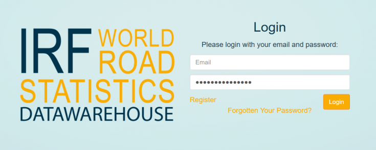
Step 1) Navigate to https://datawarehouse.worldroadstatistics.org/users/login. If necessary, register. The registration process is short, and provides immediate access to the data warehouse[[File:IRF world Road.png|center|IRF World Road Statistics Login Page|thumb|735x735px]]Step 2) Select "Country Comparison - Multiple Years" under Chart Type. | |||
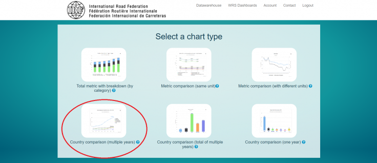
[[File:WRS IMG 2.png|center|thumb|736x736px|Select Country Comparison (Multiple Years)]] | |||
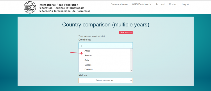
Step 3) Manually select each continent in the selection box. | |||
[[File:WRS IMG 3.png|center|thumb|734x734px|Select each continent manually]] | |||
Step 4) In the countries box, select "all countries". | |||
[[File:WRS IMG 4.png|center|thumb|741x741px|Select "All countries"]] | |||
Step 5) Under themes, select an option. Most IFs preprocessors will be under "Road Network". This example will continue with that selection. | |||
[[File:WRS IMG 5.png|center|thumb|745x745px|Select desired option under "Themes"]] | |||
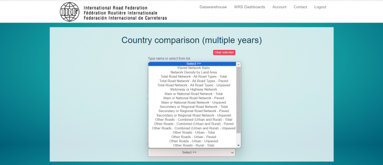
Step 6) Under "Metrics", select desired series. | |||
* For the preprocessor RoadPavedKm, select "Total Road Network- All Road Types - Paved" | |||
* For the preprocessor RoadsTotalNetwork, select "Total Road Network- All Road Types - Total" | |||
* For the preprocessor RoadsPaved%, select "Paved Network Ratio" | |||
[[File:WRS IMG 6.png|center|thumb|749x749px|Select desired series under "Metrics"]] | |||
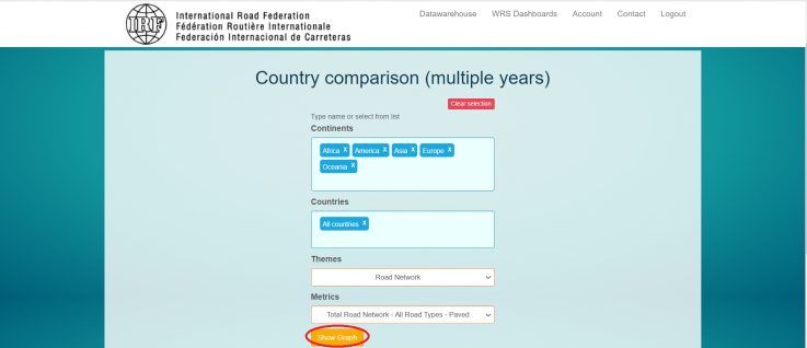
Step 7) After those four selections are complete, the Country comparison page will look like this. Select "Show Graph". | |||
[[File:WRS IMG 7.png|center|thumb|737x737px|Country completion page after selection]] | |||
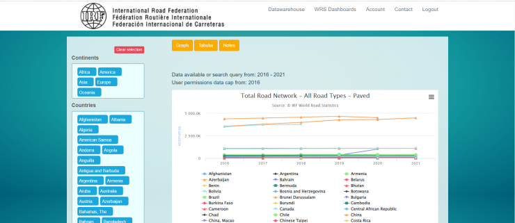
Step 8) A new page will populate. | |||
[[File:WRS IMG 8.png|center|thumb|740x740px|WRS Graph Page]] | |||
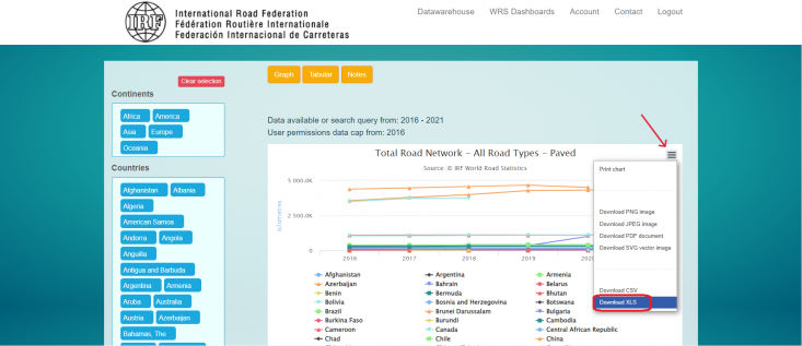
Step 9) Click on the three bar menu in the upper right corner of the graph, then "download as CSV" or "download as XLS". | |||
[[File:Screenshot (3).png|center|thumb|733x733px|Download the data series]] | |||
Step 10) An Excel sheet will download. The downloaded spreadsheet is in time series data. If necessary, pivot the Excel sheet to bring it into IFs import format. Now you can format the data to upload it into IFs. To import data into IFs, please follow the instructions found in the [[Importing data (general instructions)|Importing Data (general instructions)]] page. | |||
= Data Notes = | |||
Latest revision as of 15:51, 13 August 2025
Summary
The International Road Federation (IRF) maintains a database known as World Road Statistics (WRS), comprising over 200 series for over 200 countries. The database is a tremendous resource for infrastructure data, specifically transportation network data. WRS contains information on total road length, but also contains filters to view paved vs. unpaved roads, the kinds of traffic (commercial vs. private), the vehicles using the roadway, accidents and the consequences of them, and more.
To IFs, the IRF provides an important window into the transportation infrastructure of a country. A robust, paved road network makes it easier for a country's exporters to access ports, and for its citizens to find jobs if they are scarce locally. IFs uses three preprocessors from this data source: RoadsPavedKm, the total length of paved roads in a country measured in kilometers; RoadsTotalNetwork, the total length of roads paved or unpaved; and RoadsPaved%, the proportion of the total network which is paved.
Another table is usually updated with these three preprocessors: RuralAccessIndex. Yhe Rural Access Index measures the proportion of the rural population who live within 2 km of an all-season road. It is included in the Sustainable Development Goals as indicator 9.1.1., providing a way of measuring progress towards Goal 9 and Target 9.1. This table is pulled from the World Bank.
The latest update in IFs was in April 2025.
Tables In IFs
| Table | Definition | Extended Source Definition | Unit | Years | Source | Name in Source | Preprocessor Name |
| SeriesRoadRuralAccessIndex | Rural Access Index, proportion of the rural population who live within 2 km (25 minute walk) of all-weather road | RAI estimates the number of people who live within 2 kilometers (or about 25 minutes walking time) of the nearest all-weather road (Roberts, KC, and Rastogi 2006) | Index | 1993-2004,2009-2022 | Rural Access Index, World Bank | Rural Access Index | INFRASTRUCTURE |
| SeriesRoadsTotalNetwork | Roads, total network, kilometers | some values are filled from CIA's World Factbook, significantly inconsistent values are manually deleted. | Kilometers | 1960-2022 | World Road Statistics, International Road Federation | Total Road Network - All Road Types - Total | INFRASTRUCTURE |
| SeriesRoadsPaved% | Paved roads as a percent of total roads | some values are filled from CIA's World Factbook, significantly inconsistent values are manually deleted. | Percent | 1990-2022 | World Road Statistics, International Road Federation | Paved Network Ratio | INFRASTRUCTURE |
| SeriesRoadPavedKm | Length of paved roads, kilometers | No Extended Source | Kilometers | 1990-2010,2017-2022 | World Road Statistics, International Road Federation | Total Road Network- All Road Types - Paved | INFRASTRUCTURE |
Data Pulling Instructions
Step 1) Navigate to https://datawarehouse.worldroadstatistics.org/users/login. If necessary, register. The registration process is short, and provides immediate access to the data warehouse
Step 2) Select "Country Comparison - Multiple Years" under Chart Type.
Step 3) Manually select each continent in the selection box.
Step 4) In the countries box, select "all countries".
Step 5) Under themes, select an option. Most IFs preprocessors will be under "Road Network". This example will continue with that selection.
Step 6) Under "Metrics", select desired series.
- For the preprocessor RoadPavedKm, select "Total Road Network- All Road Types - Paved"
- For the preprocessor RoadsTotalNetwork, select "Total Road Network- All Road Types - Total"
- For the preprocessor RoadsPaved%, select "Paved Network Ratio"
Step 7) After those four selections are complete, the Country comparison page will look like this. Select "Show Graph".
Step 8) A new page will populate.
Step 9) Click on the three bar menu in the upper right corner of the graph, then "download as CSV" or "download as XLS".
Step 10) An Excel sheet will download. The downloaded spreadsheet is in time series data. If necessary, pivot the Excel sheet to bring it into IFs import format. Now you can format the data to upload it into IFs. To import data into IFs, please follow the instructions found in the Importing Data (general instructions) page.
