Rural Access Index: Difference between revisions
Norah.Shamin (talk | contribs) (Created page with "The Rural Access Index (RAI) measures the proportion of the rural population who live within 2 km of an all-season road. It is included in the Sustainable Development Goals as indicator 9.1.1., providing a way of measuring progress towards Goal 9 and Target 9.1. Originally developed by the World Bank in 2006, the RAI is among the most important global development indicators in the transport sector, providing a strong, clearly understandable and conceptually consistent in...") |
Norah.Shamin (talk | contribs) No edit summary |
||
| Line 1: | Line 1: | ||
The Rural Access Index (RAI) measures the proportion of the rural population who live within 2 km of an all-season road. It is included in the Sustainable Development Goals as indicator 9.1.1., providing a way of measuring progress towards Goal 9 and Target 9.1. Originally developed by the World Bank in 2006, the RAI is among the most important global development indicators in the transport sector, providing a strong, clearly understandable and conceptually consistent indicator across countries. Although the underlying methodology has been recently updated to leverage additional sources of data, the RAI remains the most widely accepted metric for tracking access to transport in rural areas. We use this data for | The Rural Access Index (RAI) measures the proportion of the rural population who live within 2 km of an all-season road. It is included in the Sustainable Development Goals as indicator 9.1.1., providing a way of measuring progress towards Goal 9 and Target 9.1. Originally developed by the World Bank in 2006, the RAI is among the most important global development indicators in the transport sector, providing a strong, clearly understandable and conceptually consistent indicator across countries. Although the underlying methodology has been recently updated to leverage additional sources of data, the RAI remains the most widely accepted metric for tracking access to transport in rural areas. We use this data for '''SeriesRoadRuralAccessIndex.''' | ||
== How to Pull == | |||
* Go to https://datacatalog.worldbank.org/search/dataset/0038250 | |||
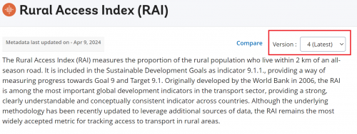
* Select the latest version of the RIA | |||
[[File:Latest Version of RIA.png|none|thumb|500x500px]] | |||
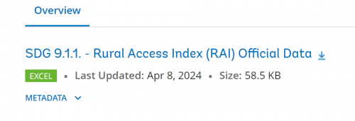
* Select the latest version of the SDG 9.1.1. - Rural Access Index (RAI) Official Data to download the data in an excel file. | |||
[[File:Rural Access Index Excel File.png|none|thumb|500x500px]] | |||
Latest revision as of 03:51, 12 May 2024
The Rural Access Index (RAI) measures the proportion of the rural population who live within 2 km of an all-season road. It is included in the Sustainable Development Goals as indicator 9.1.1., providing a way of measuring progress towards Goal 9 and Target 9.1. Originally developed by the World Bank in 2006, the RAI is among the most important global development indicators in the transport sector, providing a strong, clearly understandable and conceptually consistent indicator across countries. Although the underlying methodology has been recently updated to leverage additional sources of data, the RAI remains the most widely accepted metric for tracking access to transport in rural areas. We use this data for SeriesRoadRuralAccessIndex.
How to Pull
- Go to https://datacatalog.worldbank.org/search/dataset/0038250
- Select the latest version of the RIA
- Select the latest version of the SDG 9.1.1. - Rural Access Index (RAI) Official Data to download the data in an excel file.

