FAO Land
Jump to navigation
Jump to search
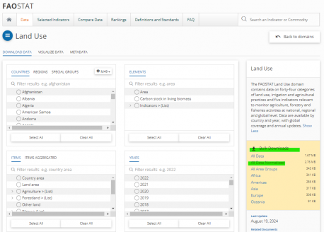
The FAOSTAT Land Use domain contains data on forty-four categories of land use, irrigation and agricultural practices and five indicators relevant to monitor agriculture, forestry and fisheries activities at national, regional and global level. Data are available by country and year, with global coverage and annual updates.
The most recent update was in Aug. 2024. IFs have 10 series in total.
Series pulled from the FAOSTAT, Land Use
| Variable | Definition | Units | Name in Source | UsedInPreprocessor | UsedInPreprocessorFileName | Code in Source |
| LandTotal | Land, total | Million ha | Item "Country area" | 1 | AGRICULTURE, INFRASTRUCTURE | 5110.6600 |
| LandArea | Land area | Million ha | Land area (1000 ha) | 1 | AGRICULTURE | 5110.6601 |
| LandGrazing | Permanent meadows and pastures | Million ha | Item "Land under perm. meadows and pastures" | 1 | AGRICULTURE | 5110.6655 |
| LandOther | Other land | Million ha | Item "Other Land" | 1 | AGRICULTURE | 5110.6670 |
| LandAgri | Agricultural land | 1000 ha | Item "Agricultural land" | 1 | INFRASTRUCTURE | 5110.6610 |
| LandCrop | Cropland | Million ha | Item "Cropland" | 1 | AGRICULTURE | 5110.6620 |
| LandForest | Forest land | Million ha | Item "Forest" | 1 | AGRICULTURE | 5110.6646 |
| LandIrArea | Agriculture area actually irrigated | 1000 ha | Item "Agriculture area actually irrigated" | 0 | 5110.6611 | |
| LandOther% | Land use, other land (% of total area) | Percent | 0 | |||
| LandPasture% | Land use, permanent pasture (% of total area) | Percent | 0 |
Instructions for pulling FAOSTAT, Land Use series
- The data can be accessed on the FAOSTAT, Land Use website.
- The importing python scripts can be accessed here.
- To download the all the data at once, you may click the "All Data Normalized" under "Bulk Downloads" on the FAOSTAT, Land Use website.
