IRF World Road Statistics: Difference between revisions
Greg.Gillen (talk | contribs) (Pulling instructions page created) |
Greg.Gillen (talk | contribs) (Reformatted and added data source summary) |
||
| Line 1: | Line 1: | ||
== Data Source Summary == | |||
The International Road Federation (IRF) maintains a database known as World Road Statistics (WRS), comprising over 200 series for over 200 countries. The database is a tremendous resource for infrastructure data, specifically transportation network data. WRS contains information on total road length, but also contains filters to view paved vs. unpaved roads, the kinds of traffic (commercial vs. private), the vehicles using the roadway, accidents and the consequences of them, and more. | |||
To IFs, the IRF provides an important window into the transportation infrastructure of a country. A robust, paved road network makes it easier for a country's exporters to access ports, and for its citizens to find jobs if they are scarce locally. IFs uses three preprocessors from this data source: RoadsPavedKm, the total length of paved roads in a country measured in kilometers; RoadsTotalNetwork, the total length of roads paved or unpaved; and RoadsPaved%, the proportion of the total network which is paved. | |||
=== Pulling Instructions: === | === Pulling Instructions: === | ||
# Navigate to https://datawarehouse.worldroadstatistics.org/users/login. If necessary, register. The registration process is short, and provides immediate access to the data warehouse | # Navigate to https://datawarehouse.worldroadstatistics.org/users/login. If necessary, register. The registration process is short, and provides immediate access to the data warehouse[[File:IRF world Road.png|center|frameless|545x545px|IRF World Road Statistics Login Page]] | ||
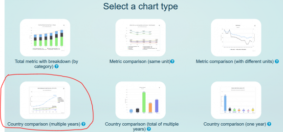
# Select "Country Comparison - Multiple Years" under Chart Type. | # Select "Country Comparison - Multiple Years" under Chart Type.[[File:Chart Type Road networks.png|center|frameless|579x579px|Select Country Comparison (Multiple Years)]] | ||
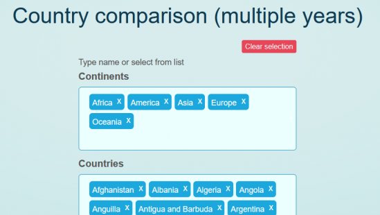
# Manually select each continent in the selection box. In the countries box, select "all countries". | # Manually select each continent in the selection box. In the countries box, select "all countries". | ||
# Under themes, select "road network" | # [[File:Continent and Country selector Road Networks.png|center|frameless|549x549px|Select each continent manually, then "all countries"]]Under themes, select "road network" | ||
# For the preprocessor RoadPavedKm, select "Total Road Network- All Road Types - Paved" | # For the preprocessor RoadPavedKm, select "Total Road Network- All Road Types - Paved" | ||
# For the preprocessor RoadsTotalNetwork, select "Total Road Network- All Road Types - Total" | # For the preprocessor RoadsTotalNetwork, select "Total Road Network- All Road Types - Total" | ||
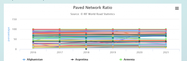
# For the preprocessor RoadsPaved%, select "Paved Network Ratio" | # For the preprocessor RoadsPaved%, select "Paved Network Ratio" | ||
# Select "Show Graph" | # Select "Show Graph" | ||
# Click on the three bar menu in the upper right corner of the graph, then "download as CSV" or "download as XLS". | # Click on the three bar menu in the upper right corner of the graph, then "download as CSV" or "download as XLS".[[File:World Road menu.png|center|frameless|632x632px|Select the three bar menu in the upper right corner of the graph]] | ||
# The downloaded spreadsheet is in time series data. If necessary, pivot the Excel sheet to bring it into IFs import format. | # The downloaded spreadsheet is in time series data. If necessary, pivot the Excel sheet to bring it into IFs import format. | ||
Revision as of 21:36, 21 September 2023
Data Source Summary
The International Road Federation (IRF) maintains a database known as World Road Statistics (WRS), comprising over 200 series for over 200 countries. The database is a tremendous resource for infrastructure data, specifically transportation network data. WRS contains information on total road length, but also contains filters to view paved vs. unpaved roads, the kinds of traffic (commercial vs. private), the vehicles using the roadway, accidents and the consequences of them, and more.
To IFs, the IRF provides an important window into the transportation infrastructure of a country. A robust, paved road network makes it easier for a country's exporters to access ports, and for its citizens to find jobs if they are scarce locally. IFs uses three preprocessors from this data source: RoadsPavedKm, the total length of paved roads in a country measured in kilometers; RoadsTotalNetwork, the total length of roads paved or unpaved; and RoadsPaved%, the proportion of the total network which is paved.
Pulling Instructions:
- Navigate to https://datawarehouse.worldroadstatistics.org/users/login. If necessary, register. The registration process is short, and provides immediate access to the data warehouse

- Select "Country Comparison - Multiple Years" under Chart Type.
- Manually select each continent in the selection box. In the countries box, select "all countries".
- Under themes, select "road network"
- For the preprocessor RoadPavedKm, select "Total Road Network- All Road Types - Paved"
- For the preprocessor RoadsTotalNetwork, select "Total Road Network- All Road Types - Total"
- For the preprocessor RoadsPaved%, select "Paved Network Ratio"
- Select "Show Graph"
- Click on the three bar menu in the upper right corner of the graph, then "download as CSV" or "download as XLS".
- The downloaded spreadsheet is in time series data. If necessary, pivot the Excel sheet to bring it into IFs import format.


