FAOSTAT Land Use
Summary
The FAOSTAT Land Use domain contains data on forty-four categories of land use, irrigation and agricultural practices and five indicators relevant to monitor agriculture, forestry and fisheries activities at national, regional and global level. Data are available by country and year, with global coverage and annual updates.
The most recent update was in August. 2025. IFs have 10 series in total.
Tables In IFs
| Variable | Definition | Units | Name in Source | UsedInPreprocessor | UsedInPreprocessorFileName | Code in Source |
| LandTotal | Land, total | Million ha | Item "Country area" | 1 | AGRICULTURE, INFRASTRUCTURE | 5110.6600 |
| LandArea | Land area | Million ha | Land area (1000 ha) | 1 | AGRICULTURE | 5110.6601 |
| LandGrazing | Permanent meadows and pastures | Million ha | Item "Land under perm. meadows and pastures" | 1 | AGRICULTURE | 5110.6655 |
| LandOther | Other land | Million ha | Item "Other Land" | 1 | AGRICULTURE | 5110.6670 |
| LandAgri | Agricultural land | 1000 ha | Item "Agricultural land" | 1 | INFRASTRUCTURE | 5110.6610 |
| LandCrop | Cropland | Million ha | Item "Cropland" | 1 | AGRICULTURE | 5110.6620 |
| LandForest | Forest land | Million ha | Item "Forest" | 1 | AGRICULTURE | 5110.6646 |
| LandIrArea | Agriculture area actually irrigated | 1000 ha | Item "Agriculture area actually irrigated" | 0 | 5110.6611 | |
| LandOther% | Land use, other land (% of total area) | Percent | LandOther/LandTotal | 0 | ||
| LandPasture% | Land use, permanent pasture (% of total area) | Percent | LandGrazing/LandTotal | 0 |
5110 is the element code and the number after it is the item code. Remember to filter both.
Data Pulling Instructions
- The data can be accessed on the FAOSTAT, Land Use website.
- The importing python scripts can be accessed here.
- To download the all the data at once, you may click the "All Data Normalized" under "Bulk Downloads" on the FAOSTAT, Land Use website.
- Filter using the element and item code.

Notes
Disaggregation
We need to disaggregate the following for previous years data
- Czechoslovakia = Slovakia and Czech Republic
- Yugoslav SFR = Slovenia, Croatia, Bosnia and Herzegovina, North Macedonia, Serbia, and Montenegro
- Serbia and Montenegro = Serbia and Montenegro
- Sudan (former) = Sudan and South Sudan
- USSR = Armenia, Azerbaijan, Belarus, Estonia, Georgia, Kazakhstan, Kyrgyzstan, Latvia, Lithuania, Moldova, Russia, Tajikistan, Turkmenistan, Ukraine, and Uzbekistan
For disaggregation you are adding up the values for the year after the state disbanded, using the data when the state existed, have the values for the new states after the entity disbanded, and then extrapolate (find the percentage of each state in the data from the OG state and then multiply it to get the right amount) data for the new states in the previous years.
- USSR add up the values for 1992; have totals for 1961-1991; have the values for 15 states for 1992; extrapolate data for 15 states 1961-1991
- Czechoslovakia add up the values for for 1993; have totals for 1961-1992; have the values for 2 states for 1993; extrapolate data for 2 states 1961-1992
- Sudan (former) add up the values for 2012; have totals for 1961-2011; have the values for 2 states for 2012; extrapolate data for 2 states 1961-2011
- Yugoslav SFR add up the values for 1992; have totals for 1961-1991; have the values for 6 states for 1992; extrapolate for 6 states 1961-1991
- Serbia and Montenegro add up the values for 2006; have totals for 1992-2005; have the values for 2 states for 2006; extrapolate data for 2 states 1992-2005
A script to do this disaggregation (as well as pulling and cleaning the data for importing) can be found here.
Notes for LandTotal and LandArea:
There is no null values in IFsHistSeries. Thus, the null values from original data need to be back filled by the earliest year's value.
Notes for Ethiopia
Use Ethiopia PDR and Ethiopia for Ethiopia's data. The two entities have roughly the same geographical coverage.
Notes for Kosovo and Serbia
- There is no value for Kosovo from FAOSTAT, Land Use. Thus, we use the resource from CIA, The World Factbook.
- Kosovo is a landlocked country. So, we fill the 1.0887 Million Ha for Kosovo from 2008 to 2022 for both LandTotal and LandArea series.
- The value for Kosovo in series LandAgri, LandGrazing, LandOther, LandCrop, and LandForest. We will use the information from CIA, The World Factbook to calculate.
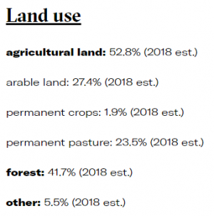
- To calculate take the 1.0087, multiply it by the variable (i.e. agricultural land). But for LandAgri multiply that value by 1000.
- Agricultural Land: LandAgri
- Permanent Crops and Arable Land: LandCrop
- Permanent Pasture: LandGrazing
- Forest: LandForest
- Other: LandOther
- To calculate take the 1.0087, multiply it by the variable (i.e. agricultural land). But for LandAgri multiply that value by 1000.
- Kosovo became independent from Serbia in 2008. Thus, the values for Serbia need to be deducted from the value for Kosovo since 2008 for each series.
